Introduction
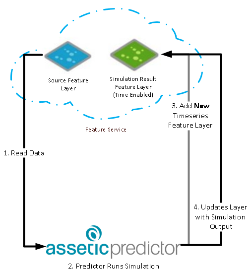
Predictor's ArcGIS Integration allows users to use hosted feature layers as the source for Predictor models as well as publish time series spatial results
Predictor integrates using the ArcGIS REST API that is deployed as part of the "Sharing" functionality in ArcGIS Portal and ArcGIS Online.
See the relevant section below for specific requirements.
ArcGIS Enterprise
Predictor integrates with Hosted Feature Layers that are deployed on ArcGIS Portal and requires the user to have Publisher and Content admin rights.
For details on configuring Predictor see ESRI Integration Configuration
The below details the specifics of
- ArcGIS Portal
- Portal ArcGIS Hosting Server
- Portal User Permissions
- Portal Hosted Feature Layer
- Portal Token Authentication
- Supported Types and Formats
Portal Requirements
ArcGIS Portal needs to be
- Federated to an ArcGIS Server (for authentication)
- linked to an ArcGIS Hosting Server (for data storage)
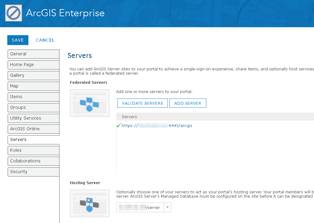
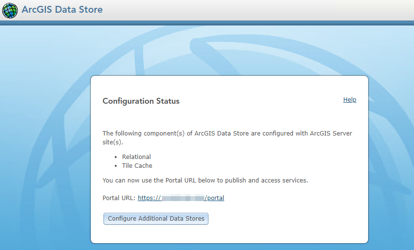
Portal ArcGIS Hosting Server
- This is an ArcGIS server connected to an ArcGIS Data Store.
- The Data Store must have a
- Relational store
- Tile Cache store.
Portal User Permissions
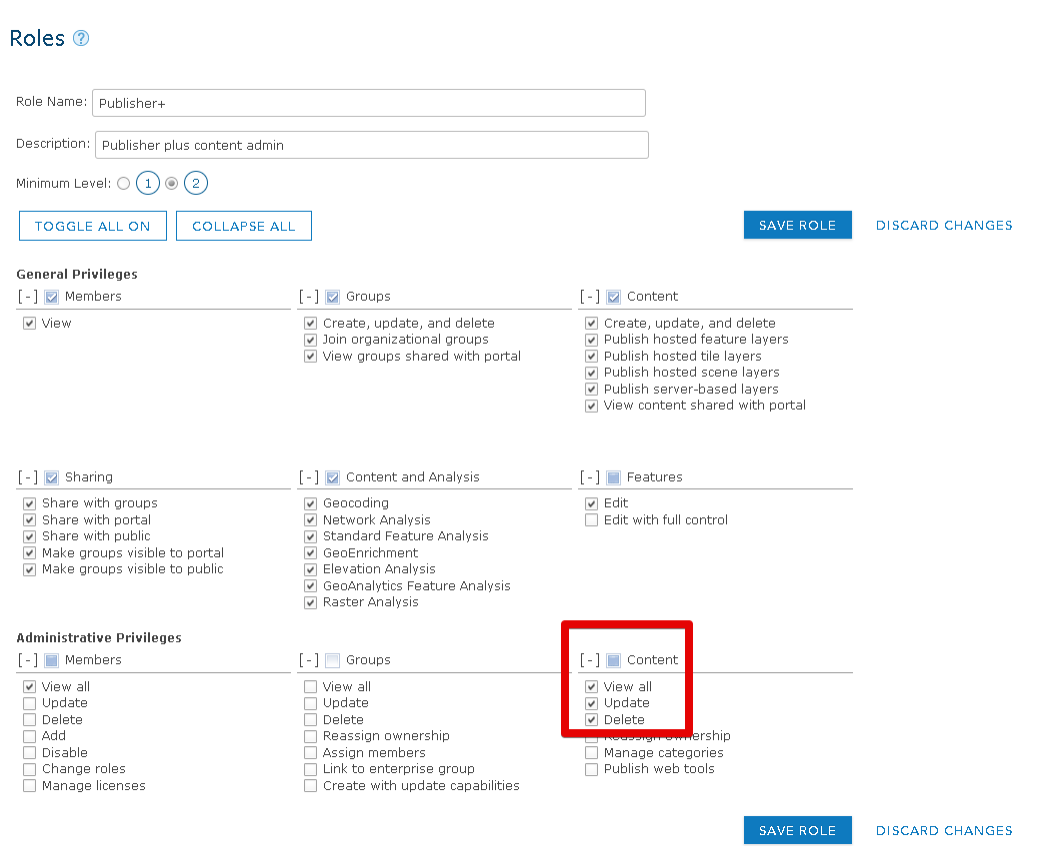
Users of the integration need to have a role with Publisher+Content Admin permissions.
It is recommended to create a new role for this purpose, that uses the in-built Publisher role as a template.

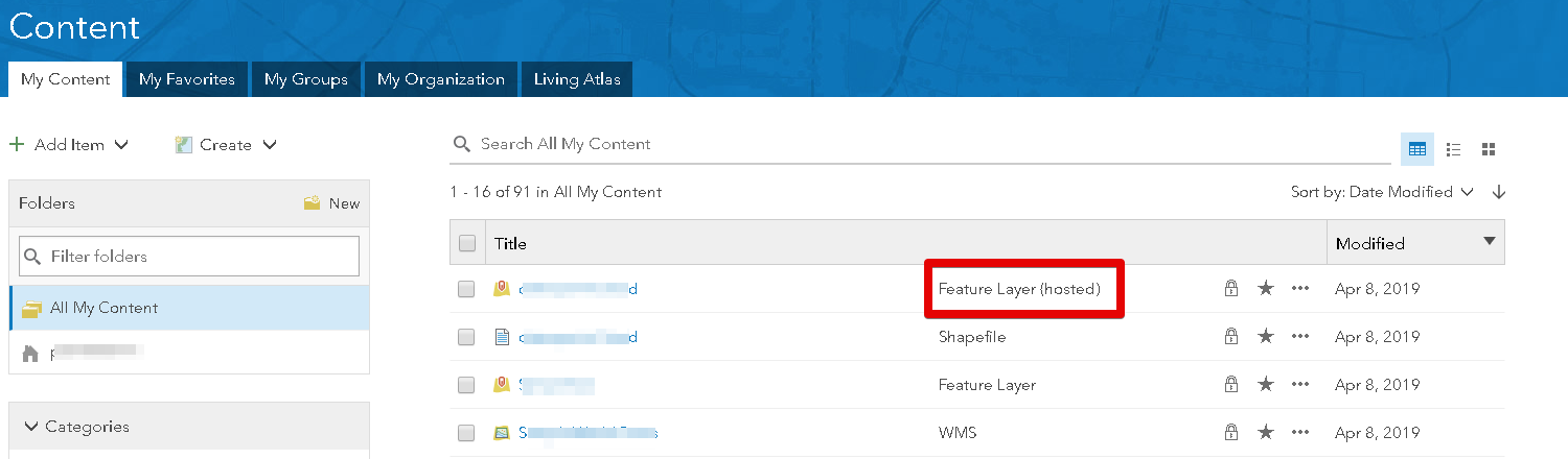
Portal Hosted Feature Layer
Predictors source Feature Layer needs to be a Hosted Feature Layer in order for Predictor to publish results back to the portal.
Supported Types and Formats
See the appendix for supported Esri types and spatial references
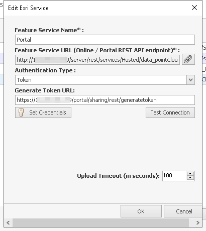
Portal Token Authentication
In an ArcGIS Enterprise scenario, several URL's exist where a user can generate an authentication token.
For Predictors integration, the Portal "sharing" token generation URL should be used.
https://<host>:<port>/<site>/sharing/rest/generateToken
ArcGIS Online
Predictor integrates with Hosted Feature Layers that are deployed on ArcGIS Online and requires a user to have Publisher and Content admin rights.
For details on configuring Predictor see ESRI Integration Configuration
The below details the specifics of
- AGOL User Permissions
- AGOL Hosted Feature Layer
- AGOL Token Authentication
- Supported Types and Formats
AGOL Requirements
AGOL User Permissions
Users of the integration need to have a role with Publisher+Content Admin permissions.
It is recommended to create a new role for this purpose, that uses the in-built Publisher role as a template.
AGOL Hosted Feature Layer
Predictors source Feature Layer needs to be a Hosted Feature Layer in order for Predictor to publish results back to ArcGIS Online.

Supported Types and Formats
See the appendix for supported Esri types and spatial references
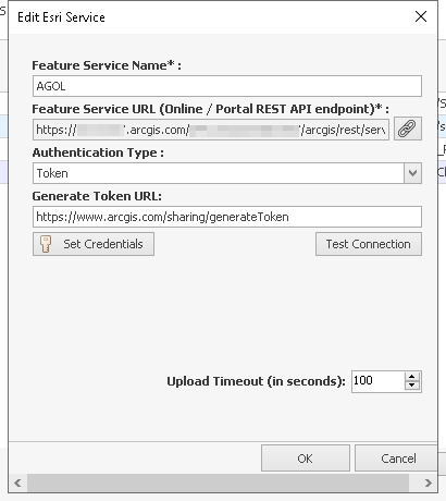
AGOL Token Authentication
For Predictors integration, the "sharing" token generation URL should be used.
Appendix - Supported Types and Formats
Not all definitions available in a feature layer can be supported by the integration. The following list itemises the supported definitions.
1. Supported ESRI Renderer Types:
- simple
- uniqueValue
- heatmap
- classBreaks
2. Supported ESRI Symbol Types:
- esriSMS (Simple Marker Symbol)
- esriSLS (Simple Line Symbol)
- esriSFS (Simple Fill Symbol)
3. Supported ESRI Symbol Styles:
- esriSMSCircle
- esriSLSSolid
- esriSFSSolid
4. Supported ESRI Field Types:
- esriFieldTypeInteger
- esriFieldTypeSmallInteger
- esriFieldTypeDouble
- esriFieldTypeSingle
- esriFieldTypeString
- esriFieldTypeDate
- esriFieldTypeGeometry
- esriFieldTypeOID
- esriFieldTypeBlob
- esriFieldTypeGlobalID
- esriFieldTypeRaster
- esriFieldTypeGUID
- esriFieldTypeXML
5. Supported spatial references (custom references not supported):
6. Supported ESRI Geometry Types:
- esriGeometryNull
- esriGeometryPoint
- esriGeometryMultipoint
- esriGeometryLine
- esriGeometryCircularArc
- esriGeometryEllipticArc
- esriGeometryBezier3Curve
- esriGeometryPath
- esriGeometryPolyline
- esriGeometryRing
- esriGeometryPolygon
- esriGeometryEnvelope
- esriGeometryAny
- esriGeometryBag
- esriGeometryMultiPatch
- esriGeometryTriangleStrip
- esriGeometryTriangleFan
- esriGeometryRay
- esriGeometrySphere
- esriGeometryTriangles
